Trail Walking Le Cailar - cailar-costieres-camargues - Photo

cailar-costieres-camargues

 v.rabot
v.rabot

User

© OpenStreetMap contributors
Length
Length
20 km
Max alt
Max alt
53 m
Uphill gradient
Uphill gradient
131 m
Km-Effort
Km-Effort  
22 km
Min alt
Min alt
-2 m
Downhill gradient
Downhill gradient
131 m
Boucle
Boucle
Yes
Creation date :
2021-06-06 06:21:00.946
Updated on :
2021-06-06 14:42:01.187

(0 Reviews)

Walking
Walking
4h00
Difficulty : Medium

Scan this QR Code to open this trail in the SityTrail application

FREE GPS app for hiking

Logo SityTrail SityTrail

IGN / Geographical institutes

Download SityTrail from the App Store Download SityTrail from Google Play

Logo SityTrail SityTrail World

The world is yours!

Download SityTrail from the App Store Download SityTrail from Google Play Download SityTrail on Huawei AppGallery

About

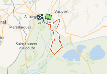
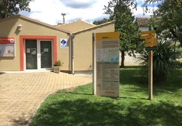
Trail Walking of 20 km to be discovered at Occitania, Gard, Le Cailar. This trail is proposed by v.rabot.

Description

Partant du Cailar, parking facile près du boulodrome, on rejoint rapidement la campagne par une belle allée de platane ombragée, on traverse les prairies par un joli chemin nous gardant au frais. On rejoint les costières de Nimes, mais on retrouve un peu d'ombre dans la montée grâce aux peupliers, on retraverse les vignes aux poteaux parfaitement alignés et on rejoint la route goudronnée qui nous mêne à la voiie verte (ne pas rater le point de vue). Sur la voie verte on évite l'accident avec les fous de vitesse et on s'empresse de retrouver la tranquillité par un joli chemin ombragé. On suit le canal du bas-rhône, puis on rejoint la ligne de crête avec de belles vues sur les montagnes, retour vers la vallée et final sur la route départementale, très peu fréquentée. Passage dans le village pour admirer l'église et la tour de l'horloge

Elevation profile

Photos

Positioning

Country:
France
Region :
Occitania
Department/Province :
Gard
Municipality :
Le Cailar
Location:
Unknown
Start:(UTM)
599630 ; 4836181 (31T) N.

Trails nearby

Trail Walking Marsillargues - vidourle et marsillargues - Photo
Walking
Prince2b

Walking

Easy
(1)
Marsillargues, Occitania, Hérault, France
7.3 km | 7.8 km-effort
1h 27min
Yes
Trail Walking Vauvert - Vauvert - Villetelle - Photo
Walking
RR31

Walking

Medium
(1)
Vauvert, Occitania, Gard, France
22 km | 23 km-effort
6h 51min
No
Trail Walking Marsillargues - marsillargues_ aymargues  - Photo
Walking
v.rabot

Walking

Medium
Marsillargues, Occitania, Hérault, France
12.3 km | 13.1 km-effort
3h 21min
Yes
Trail Walking Marsillargues - Marsillargues_Aimargues - Photo
Walking
v.rabot

Walking

Medium
Marsillargues, Occitania, Hérault, France
17.6 km | 18.8 km-effort
4h 23min
Yes
Trail Hybrid bike Vauvert - 30 - Petite Camargue GALLICIAN - Photo
Hybrid bike
chris13370

Hybrid bike

Very easy
Vauvert, Occitania, Gard, France
50 km | 53 km-effort
4h 0min
Yes
Trail Hybrid bike Vauvert - 2020-01-29_15h48m07_10922156-track-1580309276-692 - Photo
Hybrid bike
gadafo

Hybrid bike

Very easy
(1)
Vauvert, Occitania, Gard, France
50 km | 52 km-effort
Unknown
Yes
Trail Walking Vauvert - 30 VAUVERT - GR653 - chemin d'Arles - FRANQUEVAUX - d'un canal a l'autre - GALLICIAN  - ch. des Coquillons - Photo
Walking
jeff66

Walking

Difficult
Vauvert, Occitania, Gard, France
28 km | 31 km-effort
5h 1min
Yes
Trail Walking Marsillargues - vidourle et marsillargues - Photo
Walking
Prince2b

Walking

Easy
Marsillargues, Occitania, Hérault, France
7.3 km | 7.8 km-effort
1h 27min
Yes
Trail Walking Vauvert - Autour de Gallician par le canal - Photo
Walking
tracegps

Walking

Medium
Vauvert, Occitania, Gard, France
10.8 km | 11.9 km-effort
3h 0min
Yes


Close
My subscriptions